Effects of Zagyva River Paleosediments on Expected Jaszbereny Factory Groundwater Flow
Soil/Groundwater Characterization of Three Factories Located in Jaszbereny/Jaszarokszallas/Jaszboldoghaza
As Comco-Martech KFT's Characterization
Group Manager for the Lehel Electrolux Project in Hungary, one of my responsibilities, in addition to training junior multi-national
geoscientists, was to continually re-evaluate and update multi-site hydrogeology as new data were produced during field activities.
Following the dissolution of the Soviet Union in 1991, Electrolux (Sweden) purchased three existing Hungarian state-owned
factories as part of the Hungarian privatization process. The main factory was located in Jaszbereny, while the two
smaller factories were located in Jaszarokszallas and Jaszboldoghaza. The following discussion of the Jaszbereny factory
hydrogeology is based on data generated up to January 1994. Please note that the interpretation of site hydrogeology
may have been subsequently revised if new significant data have been generated since that date.
The Jaszbereny factory is underlain by a
six-aquifer groundwater system and is partially surrounded on three sides by the Zagyva River. The two shallowest aquifers,
the "7-Meter Zone" and the "12-Meter Zone", demonstrated very interesting and unexpected groundwater elevation
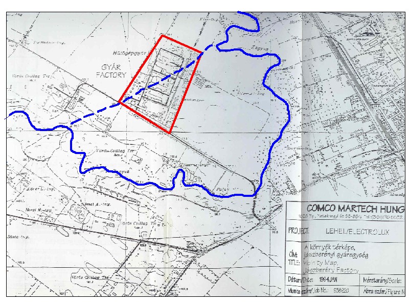
(flow) patterns with respect to regional groundwater flow conditions within the noted aquifers. Figure 1 (see link below)
shows the location of the factory ("GYAR", outlined in red) and the current path of the Zagyva River (highlighted
in blue). North is toward the top of this figure. The Zagyva River generally flows eastward, around the southern factory boundary,
and then onward through Jaszbereny. Local groundwater flow (not shown on Figure 1) within the 7-Meter and 12-Meter Zones
north and south of the factory is generally eastward toward Jaszbereny.
However, the eastward groundwater flow within both aquifers was locally redirected toward the northeast
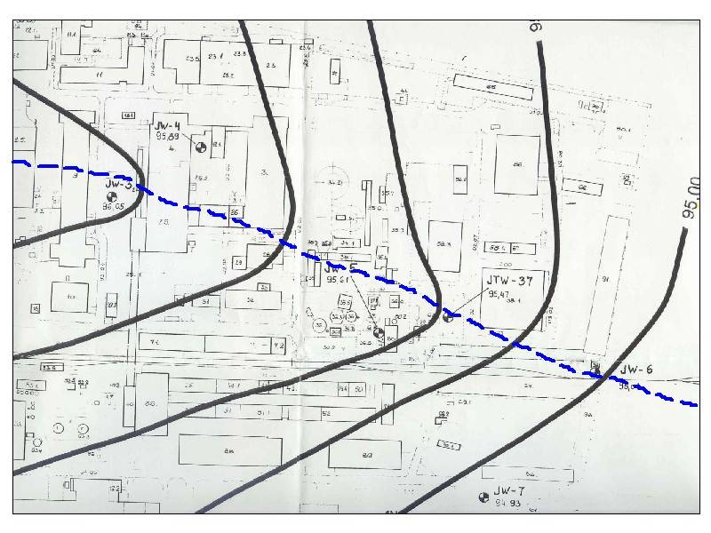
and southwest along a linear groundwater mound extending northeast across the factory (Figures 2 and 3). In both of these
figures, north is generally from the lower left-hand corner toward the upper right-hand corner. While canvassing
the factory, I noticed a northeast-trending discharge ditch located within the extreme northeast portion of the factory,
which was generally aligned with the noted linear groundwater mound. I suspected that this trench may represent
a vestigial remnant of the old riverbed of the "ancestral" Zagyva River.
After reviewing numerous groundwater
monitoring well/soil boring logs and data generated during a prior cone-penetromer (CPT) survey of the entire factory, he
developed new groundwater maps showing the lateral change in factory sediments comprising both the noted aquifers and
the separating aquitard. It became apparent from these maps that the portion of the separating aquitard underlying
the linear groundwater mound consisted of sands/gravels instead of the typical clays/silts that comprised the aquitard
to either side of the mound. A subsequent exploratory drilling program focusing in part on the axis of the groundwater mound
confirmed the lack of expected typical aquitard sediments beneath the groundwater mound. Therefore, a northeast-trending
vertically-oriented "wall" of sands/gravels cutting through the noted aquitard appears to have been deposited
by the ancestral Zagyva River, prior to its redirection around the southern factory boundary, providing a groundwater "short-cut"
for a portion of the river surface water, between two separated reaches of the Zagyva River beneath the factory. Flow
through this short-cut was significant enough to disrupt the eastward groundwater flow within the 7-Meter and 12-Meter
Zones via a hydraulic pressure "overflow" of the buried "banks" of the Zagyva River paleochannel
and then into the laterally adjacent portions of these aquifers, similar to overbank flood conditions that periodically
occur on rivers, forming the groundwater contour "V"s. The dashed blue line shown in Figures 1
through 3 indicates the approximate location of the paleosediments (paleochannel) that were deposited by the ancestral
Zagyva River, which lines up with the aforementioned trench and linear groundwater mound.
The
hydrodynamics of the short-cut are readily apparent, both laterally and vertically. Laterally, piezometric contour "V"s
are tighter within both aquifers in the southwest portion (upper left-hand corner) of both Figures 2 and 3, which represents
the "upstream" portion of the groundwater short-cut, nearest where Zagyva River water enters the short-cut.
This can be expected because as groundwater is lost to the upstream portions of the aquifers, the energy decreases in
the downstream direction of the groundwater short-cut, resulting in increased distances between and an opening of the
groundwater contour "V"s. Similarly, this is also shown vertically when comparing the piezometry of both
aquifers. For example, the 7-Meter Zone piezometry appears to be more disrupted, possibly because this aquifer
is vertically closer to the groundwater short-cut hydraulic energy source, the Zagyva River. Conversely, the 12-Meter
Zone piezometry appears to be less disrupted, possibly from most of the groundwater short-cutting (energy) having been
siphoned off by the 7-Meter Zone.
FIGURE 1
FIGURE 2
FIGURE 3
RESULT:
The new conceptualization of groundwater flow beneath the Jaszbereny factory, consisting of the effects of the Zagyva
River paleochannel on the vertically and hydraulically-connected portions of the six-aquifer groundwater system,
allowed Electrolux to better understand groundwater contaminant flow beneath this factory and appropriately modify its remedialtion
approach.
Associated document produced by me on this project:
Groundwater Remediation, Jaszbereny Factory,
Volume I, Hydrogeologic Characterization/Talajvizhelyreallitas, Jaszberenyi Gyaregyseg, I Resz, Hidrogeologiai
Elemzes (1993)
I appreciate the opportunity to have worked
with Mr. Jim Lenoci and the multi-national staff of Comco-Martech KFT, Budapest and Jaszbereny offices, Hungary.
In particular, I thank Mr. Kohler Artur for translating the noted document from the English to the Hungarian.


